Account Login/Registration
Login
Register
OR
Access KelownaNow using your Facebook account, or by entering your information below.

- News
- Opinion
- Lifestyle
- Business
- Sports
- Columns
- More
- Advertise
- Real Estate Listings
- Good News
- Energized
- Big White Ski Resort
- Best of
- Contests
- Contact Us
- Publications
- Cities
- Auctions
- Subscribe
- Events
Notice (8): Array to string conversion [APP/views/elements/active/header.ctp, line 65]
Code | Context
Array">
if (Configure::read() > 0) {include ($___viewFn);
$___viewFn = "/home/newwtk/public_html/app/views/elements/active/header.ctp"
$___dataForView = array(
"hide_login_box" => false,
"title_for_layout" => "BC Wildfire Dashboard",
"pageModules" => array(),
"adzone" => "",
"page" => array(
"id" => "909",
"sef_description" => "",
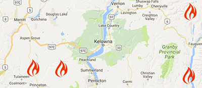
"title" => "BC Wildfire Dashboard",
"sef_keywords" => "",
"sef_url" => "ring_of_dev",
"created" => "2017-07-12 18:42:43",
"modified" => "2017-07-14 17:40:46",
"modified_by" => "82",
"is_visible" => "0",
"parent_id" => null,
"is_active" => null,
"lft" => "1365",
"rght" => "1366",
"slug" => null,
"site_id" => "1",
"sef_title" => "",
"layout_id" => "2",
"theme_id" => "1",
"photo" => "princeton1-1.JPG",
"content" => "<p>Get the latest information on BC Wildfires with our BC Wildfire Dashboard.</p>
",
"external_link" => "",
"old_parent_id" => null,
"subtitle" => "",
"force_nav" => "0",
"adzone" => "",
"youtube_link" => null,
"news_introduction" => "",
"url" => "/ring_of_dev/"
),
"left_navigation" => array(),
"facebook_meta" => array(
"photo" => "princeton1-1.JPG",
"title" => "BC Wildfire Dashboard"
),
"site_alert" => "",
"fires" => array(),
"rss_news" => array(),
"results" => array(
array(),
array(),
array(),
array(),
array(),
array(),
array()
),
"description" => "Get the latest information on BC Wildfires with the BC Wildfire Dashboard.",
"photo" => "princeton1.JPG",
"override_title" => "BC Wildfire Dashboard",
"theme_color" => "#df2a00",
"category_id" => 224,
"new_weather" => array(
"last_updated" => "2026-07-16 13:00:00",
"current" => array(),
"forecast" => array()
),
"weather" => false,
"in_focus" => false,
"hp_events" => array(
array(),
array(),
array(),
array()
),
"instagram_pic" => false,
"top_news" => array(
"current" => array()
),
"new_ads" => true,
"inject_header" => array(
"SitesInfo" => array()
),
"puppy_guilt" => array(
"SitesInfo" => array()
),
"navigation" => array(
"desktop" => array(),
"june_2019" => array()
),
"sites_list" => array(
array(),
array(),
array(),
array(),
array(),
array(),
array(),
array(),
array(),
array(),
array()
),
"site" => array(
"Site" => array()
),
"is_mobile" => false,
"member_information" => null,
"member_box" => null,
"csek" => CsekHelper
CsekHelper::$helpers = NULL
CsekHelper::$base = ""
CsekHelper::$webroot = "/"
CsekHelper::$theme = NULL
CsekHelper::$here = "/fires/"
CsekHelper::$params = array
CsekHelper::$action = "index"
CsekHelper::$plugin = NULL
CsekHelper::$data = NULL
CsekHelper::$namedArgs = NULL
CsekHelper::$argSeparator = NULL
CsekHelper::$validationErrors = NULL
CsekHelper::$tags = array
CsekHelper::$__tainted = NULL
CsekHelper::$__cleaned = NULL,
"newsAdmin" => NewsAdminHelper
NewsAdminHelper::$moduleName = "News"
NewsAdminHelper::$helpers = array
NewsAdminHelper::$view = View object
NewsAdminHelper::$base = ""
NewsAdminHelper::$webroot = "/"
NewsAdminHelper::$theme = NULL
NewsAdminHelper::$here = "/fires/"
NewsAdminHelper::$params = array
NewsAdminHelper::$action = "index"
NewsAdminHelper::$plugin = NULL
NewsAdminHelper::$data = NULL
NewsAdminHelper::$namedArgs = NULL
NewsAdminHelper::$argSeparator = NULL
NewsAdminHelper::$validationErrors = NULL
NewsAdminHelper::$tags = array
NewsAdminHelper::$__tainted = NULL
NewsAdminHelper::$__cleaned = NULL
NewsAdminHelper::$Form = FormHelper object
NewsAdminHelper::$FileUpload = FileUploadHelper object,
"classifiedsAdmin" => ClassifiedsAdminHelper
ClassifiedsAdminHelper::$moduleName = "Classifieds"
ClassifiedsAdminHelper::$helpers = array
ClassifiedsAdminHelper::$view = View object
ClassifiedsAdminHelper::$base = ""
ClassifiedsAdminHelper::$webroot = "/"
ClassifiedsAdminHelper::$theme = NULL
ClassifiedsAdminHelper::$here = "/fires/"
ClassifiedsAdminHelper::$params = array
ClassifiedsAdminHelper::$action = "index"
ClassifiedsAdminHelper::$plugin = NULL
ClassifiedsAdminHelper::$data = NULL
ClassifiedsAdminHelper::$namedArgs = NULL
ClassifiedsAdminHelper::$argSeparator = NULL
ClassifiedsAdminHelper::$validationErrors = NULL
ClassifiedsAdminHelper::$tags = array
ClassifiedsAdminHelper::$__tainted = NULL
ClassifiedsAdminHelper::$__cleaned = NULL
ClassifiedsAdminHelper::$Form = FormHelper object
ClassifiedsAdminHelper::$FileUpload = FileUploadHelper object,
"time" => TimeHelper
TimeHelper::$helpers = NULL
TimeHelper::$base = ""
TimeHelper::$webroot = "/"
TimeHelper::$theme = NULL
TimeHelper::$here = "/fires/"
TimeHelper::$params = array
TimeHelper::$action = "index"
TimeHelper::$plugin = NULL
TimeHelper::$data = NULL
TimeHelper::$namedArgs = NULL
TimeHelper::$argSeparator = NULL
TimeHelper::$validationErrors = NULL
TimeHelper::$tags = array
TimeHelper::$__tainted = NULL
TimeHelper::$__cleaned = NULL,
"eventsAdmin" => EventsAdminHelper
EventsAdminHelper::$moduleName = "Events"
EventsAdminHelper::$helpers = array
EventsAdminHelper::$view = View object
EventsAdminHelper::$base = ""
EventsAdminHelper::$webroot = "/"
EventsAdminHelper::$theme = NULL
EventsAdminHelper::$here = "/fires/"
EventsAdminHelper::$params = array
EventsAdminHelper::$action = "index"
EventsAdminHelper::$plugin = NULL
EventsAdminHelper::$data = NULL
EventsAdminHelper::$namedArgs = NULL
EventsAdminHelper::$argSeparator = NULL
EventsAdminHelper::$validationErrors = NULL
EventsAdminHelper::$tags = array
EventsAdminHelper::$__tainted = NULL
EventsAdminHelper::$__cleaned = NULL
EventsAdminHelper::$Form = FormHelper object
EventsAdminHelper::$FileUpload = FileUploadHelper object
EventsAdminHelper::$Time = TimeHelper object,
"text" => TextHelper
TextHelper::$helpers = NULL
TextHelper::$base = ""
TextHelper::$webroot = "/"
TextHelper::$theme = NULL
TextHelper::$here = "/fires/"
TextHelper::$params = array
TextHelper::$action = "index"
TextHelper::$plugin = NULL
TextHelper::$data = NULL
TextHelper::$namedArgs = NULL
TextHelper::$argSeparator = NULL
TextHelper::$validationErrors = NULL
TextHelper::$tags = array
TextHelper::$__tainted = NULL
TextHelper::$__cleaned = NULL,
"cache" => CacheHelper
CacheHelper::$__replace = array
CacheHelper::$__match = array
CacheHelper::$cacheAction = NULL
CacheHelper::$_counter = 0
CacheHelper::$helpers = NULL
CacheHelper::$base = ""
CacheHelper::$webroot = "/"
CacheHelper::$theme = NULL
CacheHelper::$here = "/fires/"
CacheHelper::$params = array
CacheHelper::$action = "index"
CacheHelper::$plugin = NULL
CacheHelper::$data = NULL
CacheHelper::$namedArgs = NULL
CacheHelper::$argSeparator = NULL
CacheHelper::$validationErrors = NULL
CacheHelper::$tags = array
CacheHelper::$__tainted = NULL
CacheHelper::$__cleaned = NULL,
"fileUpload" => FileUploadHelper
FileUploadHelper::$helpers = array
FileUploadHelper::$fileName = NULL
FileUploadHelper::$FileUpload = NULL
FileUploadHelper::$inputCount = 0
FileUploadHelper::$options = array
FileUploadHelper::$settings = array
FileUploadHelper::$base = ""
FileUploadHelper::$webroot = "/"
FileUploadHelper::$theme = NULL
FileUploadHelper::$here = "/fires/"
FileUploadHelper::$params = array
FileUploadHelper::$action = "index"
FileUploadHelper::$plugin = NULL
FileUploadHelper::$data = NULL
FileUploadHelper::$namedArgs = NULL
FileUploadHelper::$argSeparator = NULL
FileUploadHelper::$validationErrors = NULL
FileUploadHelper::$tags = array
FileUploadHelper::$__tainted = NULL
FileUploadHelper::$__cleaned = NULL
FileUploadHelper::$FileUploadSettings = FileUploadSettings object
FileUploadHelper::$Html = HtmlHelper object
FileUploadHelper::$Form = FormHelper object,
"jqueryEngine" => JqueryEngineHelper
JqueryEngineHelper::$_optionMap = array
JqueryEngineHelper::$_callbackArguments = array
JqueryEngineHelper::$jQueryObject = "$"
JqueryEngineHelper::$useNative = true
JqueryEngineHelper::$selection = NULL
JqueryEngineHelper::$bufferedMethods = array
JqueryEngineHelper::$helpers = NULL
JqueryEngineHelper::$base = ""
JqueryEngineHelper::$webroot = "/"
JqueryEngineHelper::$theme = NULL
JqueryEngineHelper::$here = "/fires/"
JqueryEngineHelper::$params = array
JqueryEngineHelper::$action = "index"
JqueryEngineHelper::$plugin = NULL
JqueryEngineHelper::$data = NULL
JqueryEngineHelper::$namedArgs = NULL
JqueryEngineHelper::$argSeparator = NULL
JqueryEngineHelper::$validationErrors = NULL
JqueryEngineHelper::$tags = array
JqueryEngineHelper::$__tainted = NULL
JqueryEngineHelper::$__cleaned = NULL,
"js" => JsHelper
JsHelper::$bufferScripts = true
JsHelper::$helpers = array
JsHelper::$__jsVars = array
JsHelper::$__bufferedScripts = array
JsHelper::$__engineName = "JqueryEngine"
JsHelper::$setVariable = "app"
JsHelper::$base = ""
JsHelper::$webroot = "/"
JsHelper::$theme = NULL
JsHelper::$here = "/fires/"
JsHelper::$params = array
JsHelper::$action = "index"
JsHelper::$plugin = NULL
JsHelper::$data = NULL
JsHelper::$namedArgs = NULL
JsHelper::$argSeparator = NULL
JsHelper::$validationErrors = NULL
JsHelper::$tags = array
JsHelper::$__tainted = NULL
JsHelper::$__cleaned = NULL
JsHelper::$Html = HtmlHelper object
JsHelper::$Form = FormHelper object
JsHelper::$JqueryEngine = JqueryEngineHelper object,
"form" => FormHelper
FormHelper::$helpers = array
FormHelper::$fieldset = array
FormHelper::$__options = array
FormHelper::$fields = array
FormHelper::$requestType = "post"
FormHelper::$defaultModel = NULL
FormHelper::$_inputDefaults = array
FormHelper::$base = ""
FormHelper::$webroot = "/"
FormHelper::$theme = NULL
FormHelper::$here = "/fires/"
FormHelper::$params = array
FormHelper::$action = "index"
FormHelper::$plugin = NULL
FormHelper::$data = NULL
FormHelper::$namedArgs = NULL
FormHelper::$argSeparator = NULL
FormHelper::$validationErrors = NULL
FormHelper::$tags = array
FormHelper::$__tainted = NULL
FormHelper::$__cleaned = NULL
FormHelper::$Html = HtmlHelper object,
"html" => HtmlHelper
HtmlHelper::$tags = array
HtmlHelper::$_crumbs = array
HtmlHelper::$__includedScripts = array
HtmlHelper::$_scriptBlockOptions = array
HtmlHelper::$__docTypes = array
HtmlHelper::$helpers = NULL
HtmlHelper::$base = ""
HtmlHelper::$webroot = "/"
HtmlHelper::$theme = NULL
HtmlHelper::$here = "/fires/"
HtmlHelper::$params = array
HtmlHelper::$action = "index"
HtmlHelper::$plugin = NULL
HtmlHelper::$data = NULL
HtmlHelper::$namedArgs = NULL
HtmlHelper::$argSeparator = NULL
HtmlHelper::$validationErrors = NULL
HtmlHelper::$__tainted = NULL
HtmlHelper::$__cleaned = NULL,
"session" => SessionHelper
SessionHelper::$helpers = array
SessionHelper::$__active = true
SessionHelper::$valid = false
SessionHelper::$error = array
SessionHelper::$_userAgent = ""
SessionHelper::$path = "/"
SessionHelper::$lastError = 2
SessionHelper::$security = "high"
SessionHelper::$time = 1784238237
SessionHelper::$sessionTime = 1788558237
SessionHelper::$cookieLifeTime = false
SessionHelper::$watchKeys = array
SessionHelper::$id = NULL
SessionHelper::$host = NULL
SessionHelper::$timeout = NULL
SessionHelper::$base = ""
SessionHelper::$webroot = "/"
SessionHelper::$here = "/fires/"
SessionHelper::$params = array
SessionHelper::$action = "index"
SessionHelper::$data = NULL
SessionHelper::$theme = NULL
SessionHelper::$plugin = NULL
)
$loadHelpers = false
$cached = false
$loadedHelpers = array()
$hide_login_box = false
$title_for_layout = "BC Wildfire Dashboard"
$pageModules = array()
$adzone = ""
$page = array(
"id" => "909",
"sef_description" => "",
"title" => "BC Wildfire Dashboard",
"sef_keywords" => "",
"sef_url" => "ring_of_dev",
"created" => "2017-07-12 18:42:43",
"modified" => "2017-07-14 17:40:46",
"modified_by" => "82",
"is_visible" => "0",
"parent_id" => null,
"is_active" => null,
"lft" => "1365",
"rght" => "1366",
"slug" => null,
"site_id" => "1",
"sef_title" => "",
"layout_id" => "2",
"theme_id" => "1",
"photo" => "princeton1-1.JPG",
"content" => "<p>Get the latest information on BC Wildfires with our BC Wildfire Dashboard.</p>
",
"external_link" => "",
"old_parent_id" => null,
"subtitle" => "",
"force_nav" => "0",
"adzone" => "",
"youtube_link" => null,
"news_introduction" => "",
"url" => "/ring_of_dev/"
)
$left_navigation = array()
$facebook_meta = array(
"photo" => "princeton1-1.JPG",
"title" => "BC Wildfire Dashboard"
)
$site_alert = ""
$fires = array()
$rss_news = array()
$results = array(
array(
"title" => "Smoke from new wildfire west of Hwy 33 visible from Big White",
"link" => "/watercooler/news/news/Wildfire/Smoke_from_new_wildfire_west_of_Hwy_33_visible_from_Big_White/",
"sub_title" => "Wildfire",
"section" => "Watercooler",
"section_colour" => "016DB0",
"sub_title_link" => "/watercooler/news/news/Wildfire/",
"photo" => "wildfire2-1.jpg",
"entered" => "2026-07-16 14:30:00",
"local" => 1
),
array(
"title" => "UPDATE: Wildfire alongside the Coquihalla grows to 15 hectares",
"link" => "/watercooler/news/news/Wildfire/New_wildfire_beside_Coquihalla_not_a_threat_to_the_highway_BCWS/",
"sub_title" => "Wildfire",
"section" => "Watercooler",
"section_colour" => "016DB0",
"sub_title_link" => "/watercooler/news/news/Wildfire/",
"photo" => "coquihalla3.jpg",
"entered" => "2026-07-16 12:45:00",
"local" => 1
),
array(
"title" => "BC pilot killed in helicopter crash while fighting Colorado wildfire",
"link" => "/watercooler/news/news/Wildfire/BC_pilot_killed_in_helicopter_crash_while_fighting_Colorado_wildfire/",
"sub_title" => "Wildfire",
"section" => "Watercooler",
"section_colour" => "016DB0",
"sub_title_link" => "/watercooler/news/news/Wildfire/",
"photo" => "usgov.png",
"entered" => "2026-07-14 05:45:00",
"local" => 1
),
array(
"title" => "UPDATE: Structures destroyed as Ainslie Creek wildfire explodes to 17,000 hectares",
"link" => "/watercooler/news/news/Wildfire/More_evacuation_orders_issued_as_BC_wildfire_closes_Hwy_1/",
"sub_title" => "Wildfire",
"section" => "Watercooler",
"section_colour" => "016DB0",
"sub_title_link" => "/watercooler/news/news/Wildfire/",
"photo" => "6a4fd654aabbe.jpg",
"entered" => "2026-07-09 10:00:00",
"local" => 1
),
array(
"title" => "Half of Kalamoir Regional Park will reopen today just over 2 weeks after wildfire",
"link" => "/watercooler/news/news/Wildfire/Half_of_Kalamoir_Regional_Park_will_reopen_today_just_over_2_weeks_after_wildfire/",
"sub_title" => "Wildfire",
"section" => "Watercooler",
"section_colour" => "016DB0",
"sub_title_link" => "/watercooler/news/news/Wildfire/",
"photo" => "kalamoir4.jpg",
"entered" => "2026-07-03 06:30:00",
"local" => 1
),
array(
"title" => "Kalamoir Regional Park wildfire declared out",
"link" => "/watercooler/news/news/Wildfire/Kalamoir_Regional_Park_wildfire_declared_out/",
"sub_title" => "Wildfire",
"section" => "Watercooler",
"section_colour" => "016DB0",
"sub_title_link" => "/watercooler/news/news/Wildfire/",
"photo" => "kalamoir.jpg",
"entered" => "2026-06-30 10:10:00",
"local" => 1
),
array(
"title" => "UPDATE: Wildfire near Lytton now 'under control' at just over 700 hectares, Hwy 1 reopens",
"link" => "/watercooler/news/news/Wildfire/Hwy_1_closed_as_new_wildfire_grows_quickly_near_Lytton/",
"sub_title" => "Wildfire",
"section" => "Watercooler",
"section_colour" => "016DB0",
"sub_title_link" => "/watercooler/news/news/Wildfire/",
"photo" => "6a3af6f324607.jpg",
"entered" => "2026-06-23 17:15:00",
"local" => 1
)
)
$description = "Get the latest information on BC Wildfires with the BC Wildfire Dashboard."
$photo = "princeton1.JPG"
$override_title = "BC Wildfire Dashboard"
$theme_color = "#df2a00"
$category_id = 224
$new_weather = array(
"last_updated" => "2026-07-16 13:00:00",
"current" => array(
"description" => "Sunny",
"temperature" => "29.9",
"visibility" => "16km",
"humidity" => "28%",
"humidex" => "",
"dewpoint" => "9.5°C",
"wind" => "N35km/hgust45km/h",
"airqualityhealthindex" => "3",
"pressure" => "101.1kPa",
"image" => "https://cdn.csekcreative.com/weather/images/icons/clear.png"
),
"forecast" => array(
"2026-07-16" => array(),
"2026-07-17" => array(),
"2026-07-18" => array(),
"2026-07-19" => array(),
"2026-07-20" => array(),
"2026-07-21" => array(),
"2026-07-22" => array(),
"2026-07-23" => array()
)
)
$weather = false
$in_focus = false
$hp_events = array(
array(
"Event" => array(),
"EventsDate" => array(),
"Category" => array()
),
array(
"Event" => array(),
"EventsDate" => array(),
"Category" => array()
),
array(
"Event" => array(),
"EventsDate" => array(),
"Category" => array()
),
array(
"Event" => array(),
"EventsDate" => array(),
"Category" => array()
)
)
$instagram_pic = false
$top_news = array(
"current" => array(
array(),
array(),
array(),
array(),
array(),
array(),
array(),
array()
)
)
$new_ads = true
$inject_header = array(
"SitesInfo" => array(
"id" => "14",
"site_id" => "1",
"key" => "inject_header",
"value" => "<script id="mcjs">!function(c,h,i,m,p){m=c.createElement(h),p=c.getElementsByTagName(h)[0],m.async=1,m.src=i,p.parentNode.insertBefore(m,p)}(document,"script","https://chimpstatic.com/mcjs-connected/js/users/a1470d88678530bc45f3082aa/7f4ce7f4441e0646c0fcc6973.js");</script>
"
)
)
$puppy_guilt = array(
"SitesInfo" => array(
"id" => "8",
"site_id" => "1",
"key" => "puppy_guilt",
"value" => "1"
)
)
$navigation = array(
"desktop" => array(
"menu" => array(),
"items" => array()
),
"june_2019" => array(
"menu" => array(),
"items" => array()
)
)
$sites_list = array(
array(
"Site" => array()
),
array(
"Site" => array()
),
array(
"Site" => array()
),
array(
"Site" => array()
),
array(
"Site" => array()
),
array(
"Site" => array()
),
array(
"Site" => array()
),
array(
"Site" => array()
),
array(
"Site" => array()
),
array(
"Site" => array()
),
array(
"Site" => array()
)
)
$site = array(
"Site" => array(
"id" => "1",
"url" => "www.kelownanow.com",
"name" => "KelownaNow",
"created" => null,
"modified" => "2025-04-11 08:11:34",
"is_ecommerce" => null,
"google_id" => "UA-3724500-13",
"timezone" => "America/Vancouver",
"logo" => "NowMediaKelownaNow-05-1.png",
"logo_white" => "5de056eb-a144-444b-ab79-4bc3d8b0b5a6.png",
"merchant_id" => null,
"weather_id" => "",
"facebook_api_key" => "197376200331145",
"facebook_app_secret" => "5813c93208cbff19e6ac0f0f1c634b5e",
"rottentomatoes_api_key" => "",
"city" => "Kelowna",
"url_nice" => "",
"background_image" => "650224f06329a.jpg",
"background_start" => "2023-09-30 00:00:00",
"background_end" => "2023-10-01 23:45:00",
"background2_image" => "6452d1e96e177.png",
"background2_start" => "2023-05-26 14:00:00",
"background2_end" => "2023-05-28 14:00:00",
"alert" => "",
"square_logo" => "57c0516d-21f8-4b0e-b782-0c7ed8a83521.jpg",
"spring" => "576d5cfb-2634-42a4-a0f8-301fd8a83521.png",
"summer" => "576d5cfb-b52c-4103-8e9a-301fd8a83521.png",
"fall" => "576d5cfb-01bc-4be4-94cb-301fd8a83521.png",
"winter" => "576d5cfb-4230-47a5-b7e3-301fd8a83521.png",
"homepage_id" => "444",
"show_in_navigation" => "1",
"navigation_slug" => "june_2019"
)
)
$is_mobile = false
$member_information = null
$member_box = null
$csek = CsekHelper
CsekHelper::$helpers = NULL
CsekHelper::$base = ""
CsekHelper::$webroot = "/"
CsekHelper::$theme = NULL
CsekHelper::$here = "/fires/"
CsekHelper::$params = array
CsekHelper::$action = "index"
CsekHelper::$plugin = NULL
CsekHelper::$data = NULL
CsekHelper::$namedArgs = NULL
CsekHelper::$argSeparator = NULL
CsekHelper::$validationErrors = NULL
CsekHelper::$tags = array
CsekHelper::$__tainted = NULL
CsekHelper::$__cleaned = NULL
$newsAdmin = NewsAdminHelper
NewsAdminHelper::$moduleName = "News"
NewsAdminHelper::$helpers = array
NewsAdminHelper::$view = View object
NewsAdminHelper::$base = ""
NewsAdminHelper::$webroot = "/"
NewsAdminHelper::$theme = NULL
NewsAdminHelper::$here = "/fires/"
NewsAdminHelper::$params = array
NewsAdminHelper::$action = "index"
NewsAdminHelper::$plugin = NULL
NewsAdminHelper::$data = NULL
NewsAdminHelper::$namedArgs = NULL
NewsAdminHelper::$argSeparator = NULL
NewsAdminHelper::$validationErrors = NULL
NewsAdminHelper::$tags = array
NewsAdminHelper::$__tainted = NULL
NewsAdminHelper::$__cleaned = NULL
NewsAdminHelper::$Form = FormHelper object
NewsAdminHelper::$FileUpload = FileUploadHelper object
$classifiedsAdmin = ClassifiedsAdminHelper
ClassifiedsAdminHelper::$moduleName = "Classifieds"
ClassifiedsAdminHelper::$helpers = array
ClassifiedsAdminHelper::$view = View object
ClassifiedsAdminHelper::$base = ""
ClassifiedsAdminHelper::$webroot = "/"
ClassifiedsAdminHelper::$theme = NULL
ClassifiedsAdminHelper::$here = "/fires/"
ClassifiedsAdminHelper::$params = array
ClassifiedsAdminHelper::$action = "index"
ClassifiedsAdminHelper::$plugin = NULL
ClassifiedsAdminHelper::$data = NULL
ClassifiedsAdminHelper::$namedArgs = NULL
ClassifiedsAdminHelper::$argSeparator = NULL
ClassifiedsAdminHelper::$validationErrors = NULL
ClassifiedsAdminHelper::$tags = array
ClassifiedsAdminHelper::$__tainted = NULL
ClassifiedsAdminHelper::$__cleaned = NULL
ClassifiedsAdminHelper::$Form = FormHelper object
ClassifiedsAdminHelper::$FileUpload = FileUploadHelper object
$time = TimeHelper
TimeHelper::$helpers = NULL
TimeHelper::$base = ""
TimeHelper::$webroot = "/"
TimeHelper::$theme = NULL
TimeHelper::$here = "/fires/"
TimeHelper::$params = array
TimeHelper::$action = "index"
TimeHelper::$plugin = NULL
TimeHelper::$data = NULL
TimeHelper::$namedArgs = NULL
TimeHelper::$argSeparator = NULL
TimeHelper::$validationErrors = NULL
TimeHelper::$tags = array
TimeHelper::$__tainted = NULL
TimeHelper::$__cleaned = NULL
$eventsAdmin = EventsAdminHelper
EventsAdminHelper::$moduleName = "Events"
EventsAdminHelper::$helpers = array
EventsAdminHelper::$view = View object
EventsAdminHelper::$base = ""
EventsAdminHelper::$webroot = "/"
EventsAdminHelper::$theme = NULL
EventsAdminHelper::$here = "/fires/"
EventsAdminHelper::$params = array
EventsAdminHelper::$action = "index"
EventsAdminHelper::$plugin = NULL
EventsAdminHelper::$data = NULL
EventsAdminHelper::$namedArgs = NULL
EventsAdminHelper::$argSeparator = NULL
EventsAdminHelper::$validationErrors = NULL
EventsAdminHelper::$tags = array
EventsAdminHelper::$__tainted = NULL
EventsAdminHelper::$__cleaned = NULL
EventsAdminHelper::$Form = FormHelper object
EventsAdminHelper::$FileUpload = FileUploadHelper object
EventsAdminHelper::$Time = TimeHelper object
$text = TextHelper
TextHelper::$helpers = NULL
TextHelper::$base = ""
TextHelper::$webroot = "/"
TextHelper::$theme = NULL
TextHelper::$here = "/fires/"
TextHelper::$params = array
TextHelper::$action = "index"
TextHelper::$plugin = NULL
TextHelper::$data = NULL
TextHelper::$namedArgs = NULL
TextHelper::$argSeparator = NULL
TextHelper::$validationErrors = NULL
TextHelper::$tags = array
TextHelper::$__tainted = NULL
TextHelper::$__cleaned = NULL
$cache = CacheHelper
CacheHelper::$__replace = array
CacheHelper::$__match = array
CacheHelper::$cacheAction = NULL
CacheHelper::$_counter = 0
CacheHelper::$helpers = NULL
CacheHelper::$base = ""
CacheHelper::$webroot = "/"
CacheHelper::$theme = NULL
CacheHelper::$here = "/fires/"
CacheHelper::$params = array
CacheHelper::$action = "index"
CacheHelper::$plugin = NULL
CacheHelper::$data = NULL
CacheHelper::$namedArgs = NULL
CacheHelper::$argSeparator = NULL
CacheHelper::$validationErrors = NULL
CacheHelper::$tags = array
CacheHelper::$__tainted = NULL
CacheHelper::$__cleaned = NULL
$fileUpload = FileUploadHelper
FileUploadHelper::$helpers = array
FileUploadHelper::$fileName = NULL
FileUploadHelper::$FileUpload = NULL
FileUploadHelper::$inputCount = 0
FileUploadHelper::$options = array
FileUploadHelper::$settings = array
FileUploadHelper::$base = ""
FileUploadHelper::$webroot = "/"
FileUploadHelper::$theme = NULL
FileUploadHelper::$here = "/fires/"
FileUploadHelper::$params = array
FileUploadHelper::$action = "index"
FileUploadHelper::$plugin = NULL
FileUploadHelper::$data = NULL
FileUploadHelper::$namedArgs = NULL
FileUploadHelper::$argSeparator = NULL
FileUploadHelper::$validationErrors = NULL
FileUploadHelper::$tags = array
FileUploadHelper::$__tainted = NULL
FileUploadHelper::$__cleaned = NULL
FileUploadHelper::$FileUploadSettings = FileUploadSettings object
FileUploadHelper::$Html = HtmlHelper object
FileUploadHelper::$Form = FormHelper object
$jqueryEngine = JqueryEngineHelper
JqueryEngineHelper::$_optionMap = array
JqueryEngineHelper::$_callbackArguments = array
JqueryEngineHelper::$jQueryObject = "$"
JqueryEngineHelper::$useNative = true
JqueryEngineHelper::$selection = NULL
JqueryEngineHelper::$bufferedMethods = array
JqueryEngineHelper::$helpers = NULL
JqueryEngineHelper::$base = ""
JqueryEngineHelper::$webroot = "/"
JqueryEngineHelper::$theme = NULL
JqueryEngineHelper::$here = "/fires/"
JqueryEngineHelper::$params = array
JqueryEngineHelper::$action = "index"
JqueryEngineHelper::$plugin = NULL
JqueryEngineHelper::$data = NULL
JqueryEngineHelper::$namedArgs = NULL
JqueryEngineHelper::$argSeparator = NULL
JqueryEngineHelper::$validationErrors = NULL
JqueryEngineHelper::$tags = array
JqueryEngineHelper::$__tainted = NULL
JqueryEngineHelper::$__cleaned = NULL
$js = JsHelper
JsHelper::$bufferScripts = true
JsHelper::$helpers = array
JsHelper::$__jsVars = array
JsHelper::$__bufferedScripts = array
JsHelper::$__engineName = "JqueryEngine"
JsHelper::$setVariable = "app"
JsHelper::$base = ""
JsHelper::$webroot = "/"
JsHelper::$theme = NULL
JsHelper::$here = "/fires/"
JsHelper::$params = array
JsHelper::$action = "index"
JsHelper::$plugin = NULL
JsHelper::$data = NULL
JsHelper::$namedArgs = NULL
JsHelper::$argSeparator = NULL
JsHelper::$validationErrors = NULL
JsHelper::$tags = array
JsHelper::$__tainted = NULL
JsHelper::$__cleaned = NULL
JsHelper::$Html = HtmlHelper object
JsHelper::$Form = FormHelper object
JsHelper::$JqueryEngine = JqueryEngineHelper object
$form = FormHelper
FormHelper::$helpers = array
FormHelper::$fieldset = array
FormHelper::$__options = array
FormHelper::$fields = array
FormHelper::$requestType = "post"
FormHelper::$defaultModel = NULL
FormHelper::$_inputDefaults = array
FormHelper::$base = ""
FormHelper::$webroot = "/"
FormHelper::$theme = NULL
FormHelper::$here = "/fires/"
FormHelper::$params = array
FormHelper::$action = "index"
FormHelper::$plugin = NULL
FormHelper::$data = NULL
FormHelper::$namedArgs = NULL
FormHelper::$argSeparator = NULL
FormHelper::$validationErrors = NULL
FormHelper::$tags = array
FormHelper::$__tainted = NULL
FormHelper::$__cleaned = NULL
FormHelper::$Html = HtmlHelper object
$html = HtmlHelper
HtmlHelper::$tags = array
HtmlHelper::$_crumbs = array
HtmlHelper::$__includedScripts = array
HtmlHelper::$_scriptBlockOptions = array
HtmlHelper::$__docTypes = array
HtmlHelper::$helpers = NULL
HtmlHelper::$base = ""
HtmlHelper::$webroot = "/"
HtmlHelper::$theme = NULL
HtmlHelper::$here = "/fires/"
HtmlHelper::$params = array
HtmlHelper::$action = "index"
HtmlHelper::$plugin = NULL
HtmlHelper::$data = NULL
HtmlHelper::$namedArgs = NULL
HtmlHelper::$argSeparator = NULL
HtmlHelper::$validationErrors = NULL
HtmlHelper::$__tainted = NULL
HtmlHelper::$__cleaned = NULL
$session = SessionHelper
SessionHelper::$helpers = array
SessionHelper::$__active = true
SessionHelper::$valid = false
SessionHelper::$error = array
SessionHelper::$_userAgent = ""
SessionHelper::$path = "/"
SessionHelper::$lastError = 2
SessionHelper::$security = "high"
SessionHelper::$time = 1784238237
SessionHelper::$sessionTime = 1788558237
SessionHelper::$cookieLifeTime = false
SessionHelper::$watchKeys = array
SessionHelper::$id = NULL
SessionHelper::$host = NULL
SessionHelper::$timeout = NULL
SessionHelper::$base = ""
SessionHelper::$webroot = "/"
SessionHelper::$here = "/fires/"
SessionHelper::$params = array
SessionHelper::$action = "index"
SessionHelper::$data = NULL
SessionHelper::$theme = NULL
SessionHelper::$plugin = NULL
$stripped = ""
$site_url = "www.kelownanow.com"include - APP/views/elements/active/header.ctp, line 65 View::_render() - COREcake/libs/view/view.php, line 736 View::element() - COREcake/libs/view/view.php, line 397 include - APP/views/layouts/content.ctp, line 5 View::_render() - COREcake/libs/view/view.php, line 736 View::renderLayout() - COREcake/libs/view/view.php, line 494 View::render() - COREcake/libs/view/view.php, line 440 Controller::render() - COREcake/libs/controller/controller.php, line 909 PagesController::pageContent() - APP/controllers/pages_controller.php, line 445 FiresController::index() - APP/controllers/fires_controller.php, line 49 Dispatcher::_invoke() - COREcake/dispatcher.php, line 204 Dispatcher::dispatch() - COREcake/dispatcher.php, line 171 [main] - APP/webroot/index.php, line 128
Account Login/Registration
Access KelownaNow using your Facebook account, or by entering your information below.

OR